West Midlands Cultural Infrastructure Map
Due to a technical problem some layers may not work, for example the Active Lives layer. We are working to fix this.
The map works best in the Microsoft Edge web browser.
View the map
View the Map Discover the cultural infrastructure in your local area
How to use the map
How to use the map Find out how to use the tool and explore all the layers!
About the map
Arts and culture bring great benefits to our region. For example, they can:
- create wealth for our economy
- bring communities together
- improve our health and wellbeing
Cultural facilities are the cornerstone of our arts and cultural ecology. This map brings together new data and information that has previously not existed in one place.
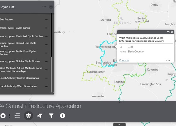
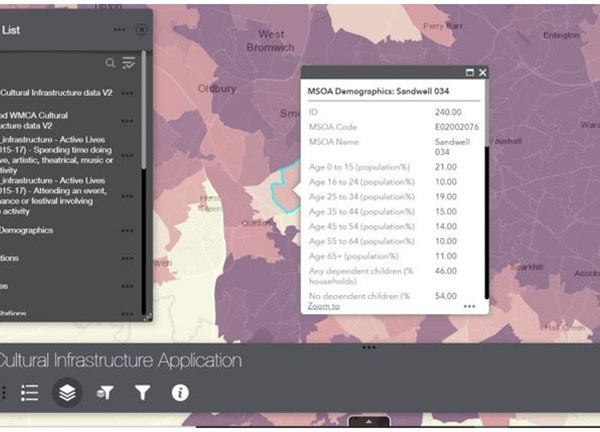
It shows the location of cultural infrastructure and enables users to view it alongside other useful data, like transport networks and demographic information.
It will help us to develop new ways to support our arts & cultural sector, and may also be useful for people and organisations working within the sector.
This map was commissioned by:
- West Midlands Combined Authority (WMCA) & WMCA Cultural Leadership Board
- Birmingham 2022 Commonwealth Games
- Coventry City of Culture Trust
- Birmingham City Council
- Greater Birmingham & Solihull Local Enterprise Partnership
- West Midlands Growth Company
- Culture Central
We also received funding from Arts Council England the Department from Digital, Culture, Media and Sport (DCMS) for this project.
The commissioners of the research contracted We Made That, Hatch and Tom Fleming Creative Consultancy to gather the information for the map, with Transport for West Midlands delivering the technical implementation. The data relating to cultural engagement was produced by Indigo-Ltd, Baker Richards, Mel Larsen and Pam Jarvis.
Further information
'Cultural infrastructure’ means physical spaces that regularly host and support creative or cultural activities as their main purpose. The cultural infrastructure map shows more than 2,350 cultural and creative spaces across WMCA Local Enterprise Partnership (LEP) areas.
You can use the map to:
- identify and analyse different types of cultural infrastructure
- compare cultural infrastructure data with other data like cultural participation, transport, demographics
- See where cultural infrastructure is situated in the region as well as identify gaps
- find cultural spaces across the West Midlands
- find out venues’ seating capacities
- download data sets
- suggest missing cultural infrastructure by emailing us at culture@wmca.org.uk
The map is not a marketing tool but the map lists websites for each piece of cultural infrastructure, where available.
We will develop the map’s functionality and keep it up to date with new data.
On the map the different types of space are grouped into:
- Arts and cultural activity are consumed and showcased (for example, museums, theatres)
- Spaces where arts and culture is produced, made or fabricated (for example, artist studios, recording studios)
- Spaces where artistic, cultural and creative activities are accessed in a participatory or communal manner (for example, community centres)
- Key environmental and heritage assets, as well as outdoor spaces used for cultural activities (for example, scheduled monuments, festival spaces)
Find out more about how we produced the map and its categories in our supporting document.
Please note: the map is not a list of all cultural organisations in the region, as some organisations may not have a physical space. For example, an arts organisation that produces mainly touring work may use other cultural spaces to share their work with the public.
If you think cultural infrastructure is missing or some of the details are not correct, contact us by sending an email to culture@wmca.org.uk.
Whilst the information contained on this platform has been formulated with all due care, the Cultural Infrastructure Map is not definitive, and discrepancies may exist. Content has been sourced from a range of third-party suppliers, online information as well as additional desktop research, and is provided to users on the basis that they undertake responsibility for assessing the relevance and accuracy of its content.
View list of data sources for the cultural infrastructure information.
The WMCA does not accept any liability to any user for the information (or the use of such information) which is provided in the map or incorporated into it by reference.
Contains data from WMCA, TfWM and WMGC sources.
Contains Active Lives survey data (2015 – 2017)
Contains OS data © Crown copyright and database rights 2021
NOTE: The data is based on Ordnance Survey mapping and the data is published under Ordnance Survey's 'presumption to publish'.